Skip to content Skip to left sidebar Skip to footer

Disaster Management

31 January 2021 Weather Alert: Severe Weather Alert – Veld Fire Conditions

Weather Alert: Severe Weather Alert – Veld Fire Conditions – 31 January 2021

Impact Based Warning for the Western Cape and Namaqua Region of Northern Cape

Legal notice:
“This warning from SA Weather Service must be communicated as received and may not be altered under any circumstance.
It must be forwarded or communicated in its entirety and no portion hereof may be replicated or copied and distributed.”

 Hazard Alert Level Affected Municipalities Valid From (SAST) Valid To (SAST)
 Veld Fire Conditions Red (L10) Beaufort West, Kannaland, Khâi-Ma, Laingsburg 31/01/21 08h00 31/01/21 20h00
 Discussion: Weather conditions which includes hot temperatures, fresh to strong winds and low humidity might result in the development of runaway and veld/bush fires.
 Impact: Conditions are such that the FDI index is above 75. Under these conditions fires may develop and spread rapidly resulting in damage to property and possible loss of human and/or animal life.
 Instruction: All personnel and equipment should be removed from the field. Fire teams, labour and equipment are to be placed on full stand-by. A first sign of smoke, every possible measure should be taken in order to bring the fire under control in the shortest possible time.

25 January 2021 Media release: Garden Route Health platform update

25 January 2021

The Garden Route District has shown a 43% decline in new COVID-19 cases the past 7 days compared to 7-14 days previously as well as a decline in hospitalisations.

“We are optimistic about the decline in numbers but remain vigilant in order to contain any cluster outbreaks through responding as early as possible. We have to maintain our momentum of surveillance and monitoring as a Department but also rely on the community to keep up with the protective behaviours (wearing a mask at all times in public, avoiding crowded spaces, avoiding spaces with poor ventilation and maintaining social distancing) that has brought about the gains which we now see”, said District Director of Health Mr Zee Brickles.

Sub-district Total Active Recovered Died
Hessequa 1 806 239 1 483 84
Mossel Bay 7 041 347 6 498 196
George 11 322 549 10 400 373
Knysna 4 680 163 4 363 154
Bitou 2 624 119 2 402 103
Kannaland 768 109 631 28
Oudtshoorn 3 687 286 3 179 222
TOTAL 31 928 1 812 28 956 1 160

Increasing our protection through vaccination                                                           

It is estimated that 1 000 000 vaccines will be made available for all frontline workers in South Africa in January, including those in the public and private sector, care workers, community health workers, etc. A further 500 000 vaccines will be made available in South Africa in February.

The roll-out will be executed in a phased approach, with the first phase targeting healthcare workers. The second phase will target essential workers, people in congregate settings, persons older than 60 years, and persons older than 18 years with comorbidities. The third phase is envisioned to target people older than 18 years who has not been vaccinated during the first two phases.

Western Cape Government will play a stewardship role. Administration of these vaccines forms part of the vaccine roll-out strategy. The Department is working on this strategy, including the logistics thereof, with the input of private sector roleplayers. More engagements on the finer details of this plan will be made available once finalised. This is a massive operation that requires a multi-sectoral approach and the support of public, private and all parts of civil society.

END

Nadia Ferreira
Principal Communications Officer
Garden Route and Central Karoo Districts
Western Cape Government Health
Town Clinic, Plettenberg Bay
Tel: 076 379 5423

Email: Nadia.Ferreira@westerncape.gov.za
Website: www.westerncape.gov.za

20 November 2020 Weather Warnings for Western Cape and Namaqua

Impact Based Warning for the Western Cape and Namaqua Region of Northern Cape:

 Hazard Alert Level Affected Municipalities Valid From (SAST) Valid To (SAST)
 Veld Fire Conditions Red(L10) Beaufort West, Hantam, Kannaland, Karoo Hoogland, Khâi-Ma, Laingsburg, Oudtshoorn, Prince Albert 21/11/20 08h00 21/11/20 18h00

Discussion: Weather conditions which includes hot temperatures, fresh to strong winds and low humidity might result in the development of veld/bush fires.

Impact: Conditions are such that the FDI index is above 75. Under these conditions fires may develop and spread rapidly resulting in damage to property and possible loss of human and/or animal life.

Instruction: All personnel and equipment should be removed from the field. Fire teams, labour and equipment are to be placed on full stand-by. At first sign of smoke, every possible measure should be taken in order to bring the fire under control in the shortest possible time.

16 November 2020 Severe Weather Alert – Disruptive Rain

The Cape Town Weather Office has issued an Impact Based Warning as follows:

Hazard: Disruptive Rain

Alert Level: Yellow(L2)

Affected Municipalities: Bitou, Cape Agulhas, George, Hessequa, Knysna, Mossel Bay and Swellendam

Valid From (SAST): 17/11/20 – 12h00

Valid To (SAST): 18/11/20 – 00h00

DISCUSSION: Significant rain is expected to affect the eastern parts of the Overberg district tomorrow afternoon, spreading to the coastal areas of the Garden Route District from late evening into Wednesday morning.The accumulated rainfall is likely to reach between 40 to 50mm over the period due to the strong southerly to south-easterly winds aided by an intense upper air system.

IMPACT: Localised flooding can be expected in susceptible formal and informal settlements and roads. Increased travel times and motor vehicle accidents may occur along with difficult driving conditions on dirt roads. Localised and short term disruption to essential services may also occur in places.

INSTRUCTION: If possible stay indoors and off the roads, avoid crossing rivers and swollen streams where water is above your ankles. If trapped in a vehicle during a flood, abandon it and climb to higher ground. In buildings, move valuables to a safe place above the expected flood level. Take caution driving on a roads covered by water. Listen to the radio or TV for warnings and obey the instructions from disaster management officers.

Report any severe weather related incidents to the Garden Route Disaster Management Centre at: 044 805 5071.

13 November 2020 Media Release: Garden Routers join efforts to remove nurdles from Mossel Bay and Hessequa coastline

Media Release: Garden Routers join efforts to remove nurdles from Mossel Bay and Hessequa coastline

For immediate release
13 November 2020

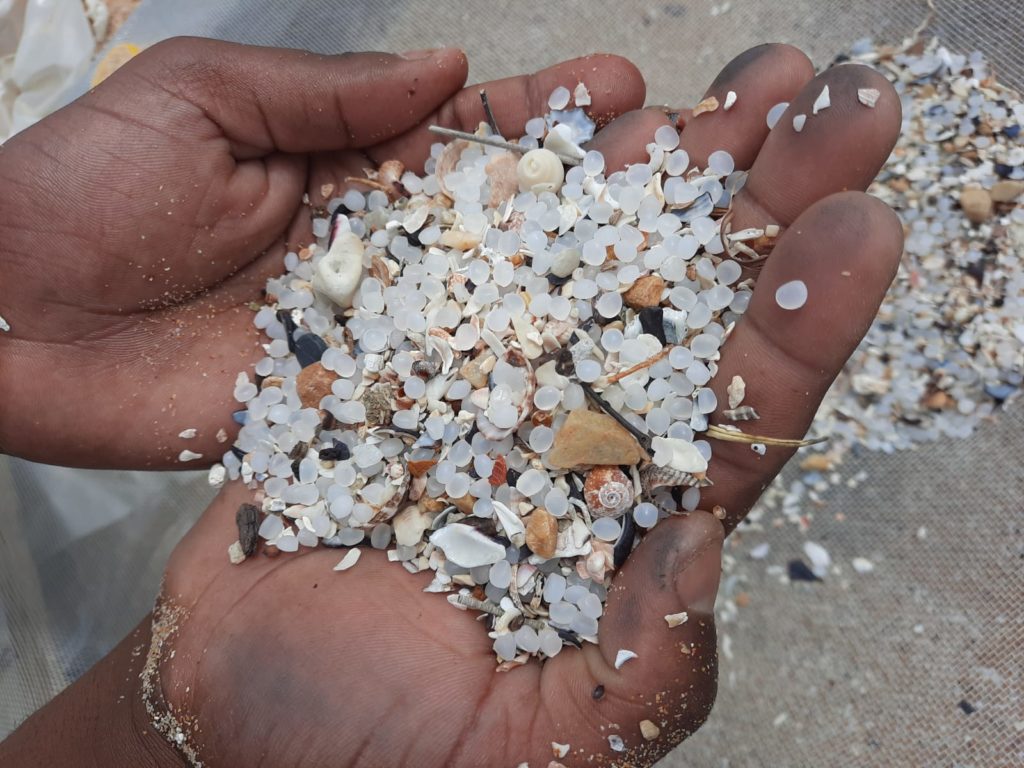
On Wednesday, 4 November and Friday, 6 November 2020, a team representing various organisations removed tens of thousands of nurdles from two beaches in Mossel Bay and Hessequa respectively. The clean-up operation took place after the nurdles were spilled along the Garden Route District Coastline during October this year.

Nurdles spilled at beaches on the Garden Route coastline.

The remnants of the spill is still a cause of concern because it poses a threat to marine life, coastal ecosystems and estuaries. According to Martina MacDonald, Disaster Management Officer at Garden Route District Municipality (GRDM), nurdles have been washing up along the Garden Route coastline, even in Cape Town and Port Elizabeth. She said:  “The source of the spill is unknown and under investigation by the South African Maritime Safety Authority, and although the identified source will be instructed to clean up, we needed to start removing the plastics from our beaches. Requests from residents from the area were also received to remove the nurdles, which indicated that communities have also been extremely concerned,” she added.

The remnants of the spill is still a cause of concern because it poses a threat to marine life, coastal ecosystems and estuaries.

Assisting the GRDM in making the clean-ups possible was the Hessequa and Mossel Bay Local Municipalities, Incident Working Group Africa and Provincial Department Environmental Affairs and Development Planning (DEA&DP).

The clean-up took place at Gouritsmond Beach on November, the 4th and Kanon Beach on November, the 6th.

Role-players involved in removing the marine debris, were:

  • GRDM Disaster Management
  • GRDM Fire and Rescue Services
  • Working on Fire (WoF)
  • Expanded Public Works Programme (EPWP)
  • Department of Environment, Forestry and Fisheries (DEFF)
  • Cape Nature
  • Hessequa Municipality
  • Southern Cape Fire Protection Association (SCFPA)
  • Incident Working Group Africa
  • Gouritsmond Conservancy Trust
  • Fransmanhoek Conservancy

Representatives from GRDM, Hessequa and Mossel Bay Local Municipalities, the Incident Working Group Africa and Provincial Department of Environmental Affairs and Development Planning (DEA&DP) during the clean-up operation.

Although the clean-up operation was carried out, not all the nurdles could be removed due to the large scale of the spill. However, every bit that was cleaned up forms an integral piece of contribution to the overall solution of the problem. For this reason, the GRDM Disaster Management Centre encourages all members of the public and residents to continue collecting nurdles and also to spread the message of the threat that it poses to marine life and the eco-system.

Dr Nina Viljoen, Disaster Risk Reduction & Climate Change Adaptation Practitioner at GRDM who drafted the initial action plan, said:  “In the raw stage (pre-moulded and packaged) new nurdles are not toxic to touch. Once released into the marine environment they will, over time, attract harmful substances from land-based pesticides, herbicides and other organic pollutants that end up in the ocean. They never go away, but they break down into tiny pieces that then get eaten by small marine organisms, and then eventually can become part of the human food chain”.

She mentioned that, “while the investigation into the source of the nurdles is being undertaken, SpillTech has been appointed to assist and conduct clean-up efforts along the affected sections of the coastline. SpillTech will also be storing the nurdles collected through clean-up efforts and are working with authorities, Non-Governmental Organisations and volunteer groups to identify collection points and arrange the pick-up of nurdles.”

Dr Viljoen called on community members to assist to remove as many nurdles from affected beaches as possible. The GRDM requested that any private individuals who collects nurdles, to make note of information listed below. This data needs to be shared with Dr Viljoen via e-mail, nina@gardenroute.gov.za, as this information is required to assist us with important research data.

Responses needed to plan additional short and long-term solutions:

  • Where nurdles have been seen?
  • Where nurdles have been collected?
  • If you have collected it, how many, i.e. black bags, etc. (nurdles collected to be weighed if possible)
  • Where have you dropped it off?
  • Have you encountered any bird or animal carcasses?

Dr Viljoen indicated that “it is important to note that nurdles should not end up in our landfill sites, as it can be ingested by animals or birds. Any collected nurdles should therefore not be disposed of in the general waste, but should be placed in a sealed bag and taken to the nearest drop-off points.” For more information regarding your nearest drop-off points, SpillTech can be contacted on 063 404 2128.

ENDS

13 November 2020 Severe Weather Alert: Impact Based Warning – Veld Fire Conditions

The Cape Town Weather Office has issued an Impact Based Warning for the Western Cape and Namaqua Region of Northern Cape, as follows:

Hazard:  Veld Fire Conditions

Alert Level: Red(L10)

Affected Municipalities: Beaufort West, Hantam, Kamiesberg, Kannaland, Karoo Hoogland, Khâi-Ma, Laingsburg, Langeberg, Nama Khoi, Oudtshoorn, Prince Albert

Valid From (SAST): 12/11/20 08h00

Valid To (SAST): 13/11/20 18h00

Discussion: Weather conditions which includes hot temperatures, fresh to strong winds and low humidity might result in the development of veld/bush fires.

Impact: Conditions are such that the FDI index is above 75. Under these conditions fires may develop and spread rapidly resulting in damage to property and possible loss of human and/or animal life.

Instruction: All personnel and equipment should be removed from the field. Fire teams, labour and equipment are to be placed on full stand-by. At first sign of smoke, every possible measure should be taken in order to bring the fire under control in the shortest possible time.

Report any severe weather related incidents to the Garden Route Disaster Management Centre at 044-805 5071.

30 September 2020 Severe Weather Alerts: Disruptive Snow and Rain & Damaging Winds

The South African Weather Service has issued the following Impact Based Severe Weather Forecast:

HAZARD 1: DISRUPTIVE SNOW

Alert Level: Yellow (L2)

Affected Municipalities: Beaufort West, Breede Valley, Kannaland, Karoo Hoogland, Laingsburg, Langeberg, Oudtshoorn, Prince Albert and Witzenberg.

Valid From (SAST): 01/10/20 00h00

Valid To (SAST): 02/10/20 00h00

Discussion: Significant low freezing levels are expected over the interior of the Western Cape and southern parts of the Northern Cape for Thursday and Friday morning due to a passage of a cold front supported by an intense upper cut-off low pressure system. Snowfall is anticipated to cover the mountainous areas during the period. Cold wet and windy weather can be expected.

Impact: Loss of vulnerable crops and livestock, especially sheep that has already been sheered. Light snow leading to icy roads high up in mountains.

Instruction: Small stock farmers are encourage to shelter animals. Dress warmly and avoid high mountain passes if possible. Make contact with your closest disaster manager or community leader and keep listening to the Radio for updates. Bring livestock in and sheltered overnight.

HAZARD 2: DAMAGING WAVES

Alert Level: Yellow (L1)

Affected Municipalities: Cape AgulhasCity of Cape town, George, Hessequa, Knysna, Mossel Bay, Overstrand, Saldanha Bay, Swartland and Table Bay.

Valid From (SAST): 30/09/20 20h00

Valid To (SAST): 02/10/20 00h00

Discussion: A deep high pressure system (center 1037hPa) accompanied by an intense upper cut-off low pressure system in the upper levels will result in strong southerly to southeasterly winds over the Northern and Western Cape provinces, including the coastal areas from late Wednesday through to early Friday morning. Swell heights are expected to reach 4 to 6m on Thursday along the entire coastlines easing off from early Friday morning. The area of concern is between Cape Columbine and Plettenberg Bay due to the southerly component of both the wind and waves.

Impact: Difficulty in navigation is likely. Small vessels are at risk of taking on water and capsizing. Localized disruptions to beachfront activities and danger to rock anglers can be expected.

Instruction: Be aware of large unpredictable waves along the coast. Small vessels are advised to seek shelter in harbours, bays or inlets. Be aware of strong rip currents especially during periods around spring tide (30 Sep 2020 – 04 October 2020).

HAZARD 3: DISRUPTIVE RAIN

Alert Level: Yellow (L2)

Affected Municipalities: Beaufort West, Bitou, Cape Agulhas, George, Hessequa, Knysna, Laingsburg, Mossel Bay, Overstrand, Swellendam and Theewaterskloof.

Valid From (SAST): 01/10/20 00h00

Valid To (SAST): 02/10/20 00h00

Discussion: Significant rain is expected for the Overberg, southern parts of the Garden Route District and Central Karoo Districts from tomorrow Thursday morning into Friday. The accumulated rainfall is likely to reach between 35 to 45mm over the period due to the strong southerly winds aided by a cut-off low pressure system in the upper levels.

Impact: Localised flooding can be expected in susceptible formal and informal settlements and roads. Increased travel times and motor vehicle accidents may occur along with difficult driving conditions on dirt roads. Localised and short term disruption to essential services may also occur in places.

Instruction: If possible stay indoors and off the roads, avoid crossing rivers and swollen streams where water is above your ankles. If trapped in a vehicle during a flood, abandon it and climb to higher ground. In buildings, move valuables to a safe place above the expected flood level. Take caution driving on a roads covered by water. Listen to the radio or TV for warnings and obey the instructions from disaster management officers.

Report any severe weather related incidents to the Garden Route Disaster Management Centre at telephone number 044 805 5071.

28 September 2020 Weather Forecast for the Week (28 September to 2 October 2020)

The Cape Town Weather Office has issued the weather outlook for the week, as follows:

A weak cold front is expected to brush through the South Western parts by late afternoon (Monday) resulting in rainfall between 0.2mm to 5mm, spreading to the South Coast by late evening. Wind is expected to reach 20 to 30km/h and slightly higher along the south and South Western coastal areas.

No significant weather predicted for Tuesday.

A cold front associated with an intense upper air system (cut-off low) is expected to affect the Province from Wednesday afternoon through to Friday morning. Accumulated rainfall amounts of 15 to 35mm are be expected in places in the Cape Metropole and Cape Winelands but 40 to 65mm in the Overberg, Garden Route and Central Karoo over the period.

Temperatures are expected to drop significantly on Thursday where Snowfalls are expected over the mountainous areas of Cape Winelands, Central Karoo and the Garden Route.

Strong and gusty southerly to South Easterly winds (45-60km/h) are expected on Wednesday through to Friday over the Province.

WIND:

Generally moderate to fresh (25 to 40km/h) Southerly to South Westerly winds are expected for the rest of the week, but strong to near gale southerly to South Easterly (50 to 62km/h) with gusts >63km/h are expected between Alexander Bay and Cape Agulhas by late Wednesday afternoon, spreading to Plettenberg Bay by the evening, persisting into Friday.

WAVES: 

 Two to 3m wave heights are expected for the rest of the week, but very rough seas with wave height of 4 to 5.5m are expected between Alexander Bay and Plettenberg Bay by late Wednesday evening into early Friday morning with south-westerly swell and periods of 10 to 12 seconds becoming southerly to South-South Easterly from Thursday morning south of Slangkop.

VISIBILITY:

 Generally good visibility is expected for the week but moderate to poor in rain and showers between Alexander Bay and Plettenberg Bay from late Wednesday evening  into early Friday morning.

Weather conditions will be monitored during the week and any further developments will be communicated if need be.

For more information, contact the Garden Route Disaster Managment Centre at 044 805 5071.

12 September 2020 Severe Weather Alerts: High Seas, Veld Fire Conditions & Damaging Winds

The Cape Town Weather Office has issued the following severe weather alerts:

Hazard 1: High Seas

Alert Level: Watch

Valid From (SAST): 13/09/20 13h00

Valid To (SAST): 14/09/20 00h00

High seas with wave heights between 6-8m is expected between Cape Point and Plettenberg Bay from tomorrow afternoon into early Monday morning (13-14/09/2020).

Hazard 2: Veld Fire Conditions

Alert Level: Warning

Valid From (SAST): 12/09/20 09h00

Valid To (SAST): 13/09/20 18h00

Veld fire conditions are expected over the Central Karoo and Little Karoo (W.Cape) today and tomorrow (12-13/09/2020).

Hazard 3: Damaging Winds

Alert Level: Warning

Valid From (SAST): 12/09/20 11h00

Valid To (SAST): 13/09/20 18h00

A gale force north westerly wind (62 to 74km/h) is expected over the Beaufort West Municipality (W.Cape) this afternoon, but including the Central and Little Karoo and eastern parts of the Cape Winelands tomorrow (12-13/09/2020). Advisory Strong north-westerly winds (50-60km/h) are expected over the Central and Little Karoo (W.Cape) this afternoon including the interior of the Western Cape tomorrow (12-13/09/2020).

Description: Storm surges / High Seas

Generally heavy seas or damaging waves are a result of strong winds blowing over a large area called a fetch combined with low pressure systems. Long period swells are often very dangerous to tankers as they may literally snap them in half. Dangerous waves or surges may also be caused by storm surges and tsunami’s resulting in widespread coastal damage and loss of life.

In oceanography, a sea state is the general condition of the free surface on a large body of water—with respect to wind waves and swell—at a certain location and moment. A sea state is characterized by statistics, including the wave height, period, and power spectrum. The sea state varies with time, as the wind conditions or swell conditions change.

Precautions: Storm surges / High Seas

Ships should “idle” into the swell and wind so that the bow of the ship always faces the oncoming swell. If in a small sailing vessel reduce the sail area and steer into the oncoming swell. If along the shore-line stay well back from the highest high water mark as Secure all hatches, doors, windows and ports. Secure all loose items in the interior.

Pump the bilge’s dry and keep pumping them dry at regular intervals. Stow away all loose gear and lash down any large items that cannot be stowed. Break out your life preservers and inform your crew that everyone will be putting them on well in advance of their necessity.

Break out emergency gear like flares and first aid kit, sea anchor, safety harnesses, etc.

Check your position and update your course as plotted on your chart. Prepare alternative routes to more protected areas. If you think you will be in for relatively long haul prepare some hot soup, coffee or stew freak waves may run up beyond the normal high water mark.

If the sea recedes exposing rock and sea bed normally not exposed immediately seek higher ground at least 50m above your current position. Do not try swimming or fishing or other marine recreation during these events. Only extremely experienced surfers will temp their fate under these conditions.

Listen to the radio or TV for warnings and obey the instructions from disaster management officers.

Contact the Garden Route Disaster Management Centre at 044 805 5071 to report any severe weather related incidents.

7 September 2020 Media Release: Donations to vulnerable communities welcomed

Media Release: Donations to vulnerable communities welcomed

For immediate release
7 September 2020

News Release: Donations to vulnerable communities welcomed

Recently the Indigo Fruit Farm in Heidelberg (Hessequa) donated two containers of naartjies respectively to the Garden Route District Municipality (GRDM) Disaster Management Centre for distribution to vulnerable communities.

Representatives of Indigo Farm and Garden Route District Municipality with the nectarines donated to the communities of the Garden Route.

The first donation was made in July and the second donation later in August 2020.  Approximately 1 360 packets of naartjies, 4 100 (kg) kilograms were collected by the GRDM team from the farm.

Mr Frank Oosthuizen, Manager at Indigo Fruit, said: “Our donation came at a time when vulnerable communities in the Garden Route needed it the most and we could therefore reach out to these households.  We are grateful to the Garden Route District Disaster Management Centre who indicated that they would be able to distribute the fruit to the local municipalities for distribution in their respective municipal areas”.

Mr Gerhard Otto, Manager of Disaster Management at GRDM, extended a word of appreciation to the Indigo Farm for their generous donation to the communities of the district.

ENDS