Impact Based Severe Weather Warnings: Damaging Winds and Veld Fire Warning
The Cape Town Weather Office has issued Impact Based Warnings for Damaging Winds valid for Monday,5 September 2022 (23:00) and Veld Fire Conditions valid for 5 September 2022 (18:00) as follows:
Legal notice:
“This warning from SA Weather Service must be communicated as received and may not be altered under any circumstance. It must be forwarded or communicated in its entirety and no portion hereof may be replicated or copied and distributed.”
Report any weather related incidents to the Garden Route Disaster Management Centre at 044 805 5071.
Impact Based Severe Weather Warning: Damaging Winds
The Cape Town Weather Office has issued an Impact Based Warning for Damaging Winds valid from 4 September (0:00) to 5 September 2022 (00:00) as follows:
Legal notice:
“This warning from SA Weather Service must be communicated as received and may not be altered under any circumstance.
It must be forwarded or communicated in its entirety and no portion hereof may be replicated or copied and distributed.”
Report weather related incidents to the Garden Route Disaster Management Centre at 044 805 5071.
Impact Based Severe Weather Warning: Veld Fire Conditions
The Cape Town Weather Office has issued an Impact Based Warning for Veld Fire Conditionsvalid from 1 September (1:00) to 2 September 2022 (18:00) as follows:
Legal notice:
“This warning from SA Weather Service must be communicated as received and may not be altered under any circumstance.
It must be forwarded or communicated in its entirety and no portion hereof may be replicated or copied and distributed.”
Report weather related incidents to the Garden Route Disaster Management Centre at 044 805 5071.
Impact Based Severe Weather Warning: Damaging Winds
The Cape Town Weather Office has issued an Impact Based Warning for Damaging Winds valid from 31 August (1:00) to 31 August 2022 (23:00) as follow:
Legal notice:
“This warning from SA Weather Service must be communicated as received and may not be altered under any circumstance.
It must be forwarded or communicated in its entirety and no portion hereof may be replicated or copied and distributed.”
Report weather related incidents to the Garden Route Disaster Management Centre at 044 805 5071.
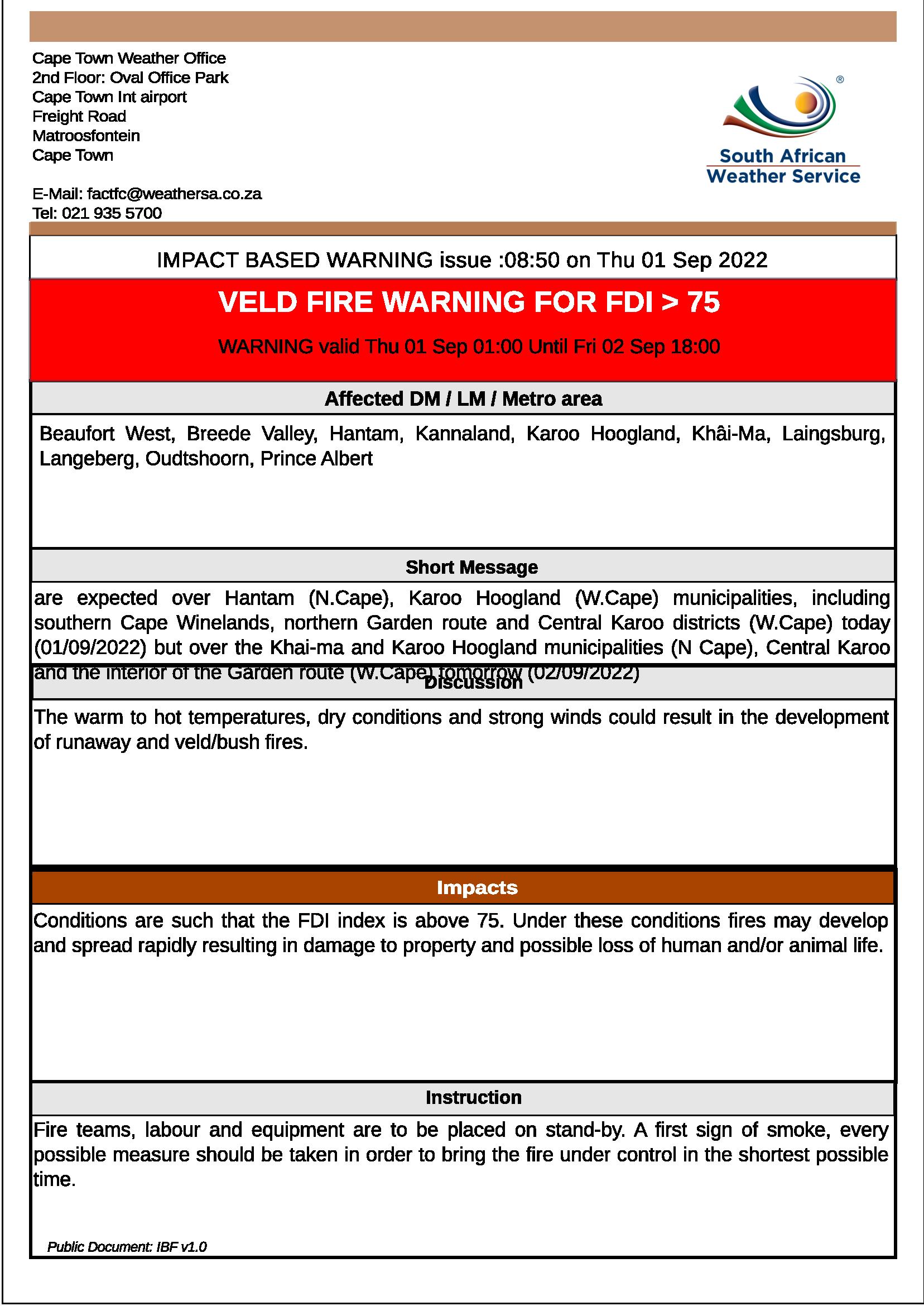
Impact Based Severe Weather Warning: Veld Fire Conditions
The Cape Town Weather Office has issued an Impact Based Warning for Veldfire Conditions valid from 23 August (8:00) to 24 August 2022 (18:00) as follow:
Legal notice:
“This warning from SA Weather Service must be communicated as received and may not be altered under any circumstance.
It must be forwarded or communicated in its entirety and no portion hereof may be replicated or copied and distributed.”
Report weather related incidents to the Garden Route Disaster Management Centre at 044 805 5071.
Impact Based Severe Weather Warning: Damaging Winds
The Cape Town Weather Office has issued an Impact Based Warning for Damaging Winds valid from 17 August (1:00) to 21 August 2022 (00:00) as follow:
Legal notice:
“This warning from SA Weather Service must be communicated as received and may not be altered under any circumstance.
It must be forwarded or communicated in its entirety and no portion hereof may be replicated or copied and distributed.”
Report weather related incidents to the Garden Route Disaster Management Centre at 044 805 5071.
Impact Based Severe Weather Warning: Damaging Winds and Disruptive Rain
The Cape Town Weather Office has issued Impact Based Warnings for Damaging Winds valid from 16 August (21:00) to 18 August 2022 (00:00) and Disruptive Rain valid from 17 August 2022 (9:00 to 23:00) as follow:
Legal notice:
“This warning from SA Weather Service must be communicated as received and may not be altered under any circumstance.
It must be forwarded or communicated in its entirety and no portion hereof may be replicated or copied and distributed.”
Report weather related incidents to the Garden Route Disaster Management Centre at 044 805 5071.
The Cape Town Weather Office has issued an Impact Based Weather Warning for Western Cape and Namaqua for Damaging Waves valid from Tuesday, 12 July 2022 (12:00) to Thursday, 14 July 2022 (00:00), as follows:
Hazard
Alert Level
Affected Municipalities
Valid From
(SAST)
Valid To
(SAST)
Damaging Waves
Yellow(L2)
(High likelihood of Minor Impacts)
M_Bitou, M_Cape Agulhas, M_Cape Agulhas, M_City of Cape Town, M_George, M_Hessequa, M_Knysna, M_Mossel Bay, M_Overstrand, M_Saldanha Bay, M_Swartland, M_Table Bay
12/07/22 – 12h00
14/07/22 – 00h00
Discussion: High energy waves with periods of between 15 and 16 seconds will result in significant south-westerly waves of 4.5 to 5.5m between Saldanha Bay and Cape Agulhas tomorrow spreading to Plettenberg Bay from Wednesday afternoon into Thursday, these conditions may result in difficulty in navigation at sea.
Impact: Difficulty in navigation at sea for small vessels and personal water crafts (e.g. kayaks) is possible, small vessels at risk of taking on water and capsizing in locality as well as localised disruptions of small harbours and ports for a short period of time.
Instruction: Small vessels are advised to seek shelter in harbours, bays or inlets.
Legal notice:
“This warning from SA Weather Service must be communicated as received and may not be altered under any circumstance.
It must be forwarded or communicated in its entirety and no portion hereof may be replicated or copied and distributed.”
Report any weather related incidents to the Garden Route Disaster Management Centre at 044-805 5071.
The Cape Town Weather Office has issued an Impact Based Weather Warning for Disruptive Rain valid from Thursday, 23 June 2022 (6:00) to Friday, 24 June 2022 (00:00), as follows:
Legal notice:
“This warning from SA Weather Service must be communicated as received and may not be altered under any circumstance.
It must be forwarded or communicated in its entirety and no portion hereof may be replicated or copied and distributed.”
Report any weather related incidents to the Garden Route Disaster Management Centre at 044-805 5071.
Media Release: Series of cold fronts headed for South Africa
For Immediate Release
09 June 2022
South Africans have been enjoying clear skies for the past few days, however, that is about to change as a series of cold fronts are expected to make landfall over the western parts of the country early next week and move eastwards, affecting most of South Africa. These cold fronts are expected to result in strong winds, high waves, heavy rainfall, light snow and a significant drop in temperatures.
Forecasted maximum temperatures for Tuesday, Wednesday and Thursday (14, 15 and 16 June 2022) next week.
The first cold front is expected to reach the Western Cape on Sunday evening. Ahead of this front, strong north-westerly winds between 50-60 km/h, gusting up to 70-80 km/h, are expected over the southern parts of the Northern Cape and interior of the Western and Eastern Cape from Sunday. These strong winds are likely to result in damage to formal and informal settlements as well as possible structural damage in these areas.
In addition, westerly to south-westerly waves, with significant wave heights of 4.0 to 4.5 m, are expected between Cape Point and Cape Agulhas on Monday morning, 13 June 2022, continuing into the afternoon. Together with these waves, strong north-westerly winds (50-60 km/h) are expected along this coast. These conditions may result in difficulty to navigate at sea.
By Monday evening, another cold front will reach the Western Cape. As these fronts make landfall, high rainfall amounts are expected mainly in the south-western parts of the Western Cape, especially from Monday through to Wednesday afternoon. This rainfall will spread eastwards on Tuesday towards the Eastern Cape. Rainfall accumulations are expected to reach 50-80 mm over the mountainous areas of the Cape Metropole, the western parts of Cape Winelands and the western parts of the Overberg districts between Monday and Wednesday. These high rainfall accumulations are likely to cause flooding of roads and formal/ informal settlements in these areas. Even though the Eastern Cape is expected to receive some rainfall, the rainfall amounts are not anticipated to have any significant effect on the dam levels for that province.
Temperatures are expected to drop significantly over the entire Western Cape and Namakwa district on Monday. This cooling will spread eastwards, reaching Limpopo, Mpumalanga as well as KwaZulu-Natal between Wednesday, 15 June 2022 and Thursday, 16 June 2022 (fig. 1).
With this cooling, freezing levels are expected to also drop significantly, resulting in light snowfall over the southern high ground of Namakwa, as well as the high-lying areas in the western interior of the Eastern Cape on Tuesday, spreading to the north-eastern high ground of the Eastern Cape on Wednesday.
The South African Weather Service will continue to monitor any further developments relating to these cold fronts and will issue updates and warnings as required. Furthermore, the public are urged to regularly follow weather forecasts on television and radio. Weather information will be available at www.weathersa.co.za as well as via the SA Weather Service Twitter account @SAWeatherServic
Compiled by Surprise Mhlongo and Elizabeth Viljoen
For technical and weather enquiries: National Forecasting Centre: Tel: 012 367 6041
Media enquiries: Ms Hannelee Doubell: Acting Senior Manager, Communications;
Tel: (012) 367 6104 / Cell: 072 222 6305;
E-mail: hannelee.doubell@weathersa.co.za