Skip to content Skip to left sidebar Skip to footer

Severe Weather Alert

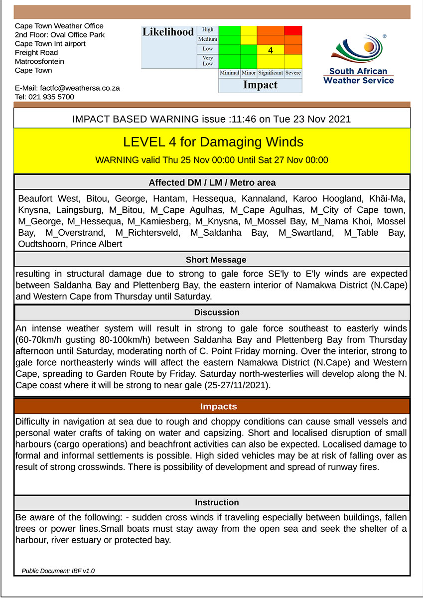
24 November 2021 Impact Based Warning: Level 8 Damaging Winds & Level 2 Damaging Waves

The Cape Town Weather Office has issued impact based warnings for (1) Level 8 Damaging Winds and (2) Level 2 Damaging Waves for the Western Cape and Namaqua Region of Northern Cape as follows:

Legal notice:
“This warning from SA Weather Service must be communicated as received and may not be altered under any circumstance. It must be forwarded or communicated in its entirety and no portion hereof may be replicated or copied and distributed.”

Report any weather related incidents to the Garden Route Disaster Management Centre at 044-805 5071.

ENDS

23 November 2021 Impact Based Weather Warning – Yellow level 4: Damaging Winds

Impact Based Weather Warning – Yellow level 4: Damaging Winds

Please find included the Impact Based Warning for the Beaufort West, Bitou, George, Hantam, Hessequa, Kannaland, Karoo Hoogland, Khai-Ma, Knysna, Laingsburg, Oudtshoorn, Bitou and Prins Albert.

“An intense weather system will result in strong to gale force southeast to easterly winds (60-70km/h gusting 80-100km/h between Saldanha Bay and Plettenberg Bay from Thursday until Saturday, moderating north of Cape Point Friday morning. Over the interior, strong to gale force northeasterly winds will affect the eastern Namakwa District (Northern Cape) and Western Cape, spreading to Garden Route by Friday. Saturday, north-westerlies will develop along the North Cape coast where it will be strong to near gale (25-27/11/2021).”

Legal notice:
“This warning from SA Weather Service must be communicated as received and may not be altered under any circumstance.
It must be forwarded or communicated in its entirety and no portion hereof may be replicated or copied and distributed.”

Report any weather related incidents to the Garden Route Disaster Management Centre at 044 805 5071.

20 November 2021 Impact Based Warning – Disruptive Rain

Impact Based Warning – Disruptive Rain

Issued: 20 November 2021

Please find below an Impact Based Warning for the Western Cape and Namaqua Region of Northern Cape

Valid from Monday 22/11/21 00h00 to 22/11/21 23h59

Report any weather-related incidents to the Garden Route Disaster Management Centre at 044 805 5071.

__________________________

Legal notice:
“This warning from SA Weather Service must be communicated as received and may not be altered under any circumstance.
It must be forwarded or communicated in its entirety and no portion hereof may be replicated or copied and distributed.”

16 November 2021 Impact Based Warning: Damaging Winds

The Cape Town Weather Office has issued a Level 1 warning for Damaging winds as follows:

Report any weather related insidents to the Garden Route Disaster Management Centre at 044-805 5071.

Legal notice:
“This warning from SA Weather Service must be communicated as received and may not be altered under any circumstance.
It must be forwarded or communicated in its entirety and no portion hereof may be replicated or copied and distributed.”

25 October 2021 Impact Based Weather Warnings for Western Cape and Namaqua: Yellow level 2: Damaging Winds

Impact Based Weather Warnings for Western Cape and Namaqua: Yellow level 2: Damaging Winds

Please find included the Impact Based Warning for the Western Cape and Namaqua Region of Northern Cape

Legal notice:
“This warning from SA Weather Service must be communicated as received and may not be altered under any circumstance.
It must be forwarded or communicated in its entirety and no portion hereof may be replicated or copied and distributed.”

Hazard Alert Level Affected Municipalities Valid From (SAST) Valid To (SAST)
Damaging Winds Yellow(L2)
(High likelihood of Minor Impacts)
M_Bitou, M_Cape Agulhas, M_Cape Agulhas, M_City of Cape town, M_George, M_Hessequa, M_Knysna, M_Mossel Bay, M_Overstrand 26/10/21 18h00 27/10/21 00h00

Discussion: Easterly to south-easterly winds are expected to increase reaching gale force (65-75km/h) off the coast between Cape Point and Plettenberg Bay from Tuesday evening and throughout Wednesday. South-easterly to easterly swells with wave heights between 4.0-4.5m are also expected along the south coast on Wednesday afternoon. This along with the strong winds will cause rough and choppy seas as well as propagating into normally sheltered areas, that are now exposed due to the south-easterly swell direction.

Impact: Difficulty in navigation at sea due to rough and choppy conditions can be expected. Small vessels and personal water crafts (e.g. kayaks) are at risk of taking on water and capsizing in a locality. Localised disruption of small harbours for a short period of time may also occur.

Instruction: Small boats must stay away from the open sea and seek the shelter of a harbour, river estuary or protected bay. Ensure that all temporary structures are well anchored.

SOUTH AFRICAN WEATHER SERVICE
Cape Town Weather Office
2nd Floor: Oval Office Park
Cape Town Int airport
Freight Road
Matroosfontein
Cape Town

E-Mail: factfc@weathersa.co.za
Tel: 021 935 5700

20 October 2021 Impact Based Warning – Severe Thunderstorms

The Cape Town Weather Office has issued the following Impact Based Warnings for the Western Cape and Namaqua Region of Northern Cape.

Report any weather related incidents to the Garden Route Disaster Management Centre at 044 805 5071.

__________________________

Legal notice:
“This warning from SA Weather Service must be communicated as received and may not be altered under any circumstance.
It must be forwarded or communicated in its entirety and no portion hereof may be replicated or copied and distributed.”

13 October 2021 Impact Based Weather Warnings for Western Cape and Namaqua: Yellow level 2: Damaging Winds

Please find included the Impact Based Warning for the Western Cape and Namaqua Region of Northern Cape

Legal notice:
“This warning from SA Weather Service must be communicated as received and may not be altered under any circumstance.
It must be forwarded or communicated in its entirety and no portion hereof may be replicated or copied and distributed.”

Hazard Alert Level Affected Municipalities Valid From (SAST) Valid To (SAST)
 Damaging Winds Yellow(L2)
(High likelihood of Minor Impacts)
M_Bitou, M_Cape Agulhas, M_Cape Agulhas, M_City of Cape town, M_George, M_Hessequa, M_Knysna, M_Mossel Bay, M_Overstrand, M_Table Bay 13/10/21 18h00 17/10/21 00h00

Discussion: A series of cold fronts are expected on Thursday and Saturday over the south western parts of the country. Resulting in strong to gale force ( NW/W 60-75km/h) winds along the south-western coastal regions on Wednesday evening into Thursday morning, and again on Saturday afternoon until Sunday morning between Table Bay and Plettenberg Bay. Alongside, wave heights of 4.0 to 5.0m are expected Thursday morning along the south-western coast, reaching 4.5 to 5.5m Saturday afternoon into Sunday morning between Table Bay and Plettenberg Bay.

Impact: Difficulty in navigation at sea for small to medium vessels and personal watercraft (e.g. kayaks) can be expected. Choppy and rough seas may lead to vessels taking on water and capsizing in the locality. Localised disruption to harbours and beachfront activities is also likely.

Instruction: Small boats must stay away from the open sea and seek the shelter of a harbour, river estuary or protected bay.

SOUTH AFRICAN WEATHER SERVICE
Cape Town Weather Office
2nd Floor: Oval Office Park
Cape Town Int airport
Freight Road
Matroosfontein
Cape Town

E-Mail: factfc@weathersa.co.za
Tel: 021 935 5700


WC_IBF_DM_Warning_Damaging_Winds_L2_13102021

9 September 2021 Weather Alert: Severe Weather Warnings – Veld Fire Conditions

9 September 2021 Weather Alert: Severe Weather Warnings: Impact Based Weather Warnings for Western Cape and Namaqua: Veld Fire Conditions

 Hazard Affected Municipalities Valid From (SAST) Valid To (SAST)
 Veld Fire Conditions Beaufort West, Bergrivier, Cederberg, Hantam, Kamiesberg, Kannaland, Karoo Hoogland, Khâi-Ma, Laingsburg, Matzikama, Nama Khoi, Oudtshoorn, Prince Albert 09/09/21 12h00 10/09/21 18h00
Discussion: The warm temperatures, dry conditions and strong winds could result in the development of runaway and veld/bush fires.
Impact: Conditions are such that the FDI index is above 75. Under these conditions, fires may develop and spread rapidly resulting in damage to property and possible loss of human and/or animal life.
Instruction: Fire teams, labour and equipment are to be placed on stand-by. At the first sign of smoke, every possible measure should be taken in order to bring the fire under control in the shortest possible time.

SOUTH AFRICAN WEATHER SERVICE
Cape Town Weather Office
2nd Floor: Oval Office Park
Cape Town Int airport
Freight Road
Matroosfontein
Cape Town

E-Mail: factfc@weathersa.co.za
Tel: 021 935 5700

Legal notice:

“This warning from SA Weather Service must be communicated as received and may not be altered under any circumstance. It must be forwarded or communicated in its entirety and no portion hereof may be replicated or copied and distributed.”

Report any weather-related incidents to the Garden Route Disaster Management Centre at: 044 805 5071.

25 August 2021 Impact Based Warning: Veld Fire Conditions

Impact Based Warning – Veld Fire Conditions

The Cape Town Weather Office has issued a Veld Fire Impact Based Warning for the Western Cape and Namaqua Region of the Northern Cape valid for 26 August 2021, as follows:

Report any weather related incidents to the Garden Route Disaster Management Centre at 044 805 5071.

END


Legal notice:
“This warning from SA Weather Service must be communicated as received and may not be altered under any circumstance.
It must be forwarded or communicated in its entirety and no portion hereof may be replicated or copied and distributed.”

18 August 2021 Impact Based Weather Warning: Disruptive Rain

Weather Warning: Impact Based Warning – Disruptive Rain

The Cape Town Weather Office has issued an Impact Based Warning for the Western Cape and Namaqua Region of the Northern Cape as follows

Report any weather related incidents to the Garden Route Disaster Management Centre at 044 805 5071.

END


Legal notice:
“This warning from SA Weather Service must be communicated as received and may not be altered under any circumstance.
It must be forwarded or communicated in its entirety and no portion hereof may be replicated or copied and distributed.”