Skip to content Skip to left sidebar Skip to footer

Severe Weather Alerts

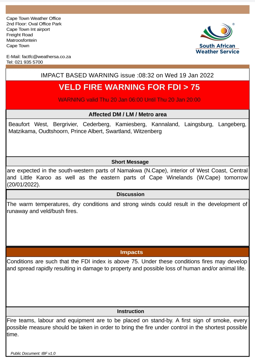
20 January 2022 Impact Based Warning – Veld Fire Conditions

The Cape Town Weather Office has issued an extended (24 hour) Impact Based Warning for the Western Cape and Namaqua Region of the Northern Cape as follows:

Hazard
Veld Fire Conditions
Affected Municipalities
Beaufort West, Bergrivier, Cederberg, Drakenstein, Hantam, Kamiesberg, Kannaland, Khâi-Ma, Laingsburg, Langeberg, Matzikama, Oudtshoorn, Prince Albert, Swartland, Witzenberg
Valid From (SAST)
20/01/22 06h00
Valid To (SAST)
21/01/22 20h00

Discussion: The warm temperatures, dry conditions and strong winds could result in the development of runaway and veld/bush fires.

Impact: Conditions are such that the FDI index is above 75. Under these conditions fires may develop and spread rapidly resulting in damage to property and possible loss of human and/or animal life.

Instruction: Fire teams, labour and equipment are to be placed on stand-by. A first sign of smoke, every possible measure should be taken in order to bring the fire under control in the shortest possible time.

Report any weather related incidents to the Garden Route Disaster Management Centre at: 044 805 5071.

________________________________________

Legal notice:
“This warning from SA Weather Service must be communicated as received and may not be altered under any circumstance.
It must be forwarded or communicated in its entirety and no portion hereof may be replicated or copied and distributed.”

_________________________________________

19 January 2022 Impact Based Warning: Veld Fire Conditions

The Cape Town Weather Office has issued the following Impact Based Warning for the Western Cape and Namaqua Region of Northern Cape:

Hazard
Veld Fire Conditions
Affected Municipalities
Beaufort West, Bergrivier, Cederberg, Kamiesberg, Kannaland, Laingsburg, Langeberg, Matzikama, Oudtshoorn, Prince Albert, Swartland, Witzenberg
Valid From (SAST)
20/01/22 06h00
Valid To (SAST)
20/01/22 20h00

Discussion: The warm temperatures, dry conditions and strong winds could result in the development of runaway and veld/bush fires.

Impact: Conditions are such that the FDI index is above 75. Under these conditions fires may develop and spread rapidly resulting in damage to property and possible loss of human and/or animal life.

Instruction: Fire teams, labour and equipment are to be placed on stand-by. A first sign of smoke, every possible measure should be taken in order to bring the fire under control in the shortest possible time.

Report any weather related incidents to the Garden Route Disaster Management Centre at: 044 805 5071.

________________________________________

Legal notice:
“This warning from SA Weather Service must be communicated as received and may not be altered under any circumstance.
It must be forwarded or communicated in its entirety and no portion hereof may be replicated or copied and distributed.”

_________________________________________

17 January 2022 Impact Based Weather Warnings for Western Cape and Namaqua: Veld Fire Conditions

Impact Based Weather Warnings for Western Cape and Namaqua: Veld Fire Conditions

17 January 2022

Hazard Affected Municipalities Valid from (SAST) Valid to (SAST)
Veld Fire Conditions Beaufort West, Kannaland, Karoo Hoogland, Laingsburg, Oudtshoorn, Prince Albert and Swellendam 18/01/22 10h00 18/01/22 18h00

Discussion: The warm temperatures, dry conditions and strong winds could result in the development of runaway and veld/bush fires.

Impact: Conditions are such that the FDI index is above 75. Under these conditions, fires may develop and spread rapidly resulting in damage to property and possible loss of human and/or animal life.

Instruction: Fireteams, labour and equipment are to be placed on stand-by. At first sign of smoke, every possible measure should be taken in order to bring the fire under control in the shortest possible time.


SOUTH AFRICAN WEATHER SERVICE
Cape Town Weather Office
2nd Floor: Oval Office Park
Cape Town Int airport
Freight Road
Matroosfontein
Cape Town

E-Mail: factfc@weathersa.co.za
Tel: 021 935 5700

Report any weather-related incidents to the Garden Route Disaster Management Centre at: 044 805 5071.

17 January 2022 Impact Based Weather Warnings for Western Cape and Namaqua: Yellow level 2: Damaging Waves

Impact Based Weather Warnings for Western Cape and Namaqua: Yellow level 2: Damaging Waves

17 January 2022

Hazard Alert Level Affected Municipalities Valid From (SAST) Valid To(SAST)
Damaging Waves Yellow(L2)
(High likelihood of Minor Impacts)
Bergrivier, Bitou, Cape Agulhas, Cape Agulhas, Cederberg, City of Cape town, George, Hessequa, Kamiesberg, Knysna, Matzikama, Mossel Bay, Nama Khoi, Overstrand, Richtersveld, Saldanha Bay, Swartland and Table Bay 18/01/22 15h00 20/01/22 00h00

Discussion: Strong to gale force SW’ly winds (50-70km/h) are expected from Tuesday afternoon between Cape Point and Plettenberg Bay. This will cause rough, choppy seas with quick successive steep waves. From Wednesday, winds drop down, but wave heights increase to 4-6m along the entire coastline (Alexander Bay to Plettenberg Bay) from the morning. Wave heights may reach 7m along the southwest coast on Wednesday. Periods of 16s is expected on Wednesday and Thursday which will result in high energy waves. Springtide this week will also result in waves reaching further up the beach.

Impact: Difficulty in navigation for small vessels and personal watercraft may lead to vessels being at risk of taking on water and capsizing. Localised disruptions of small harbours or ports is possible for short period. Localised damage to coastal infrastructure is possible (mainly Wed-Thurs). Localised disruption to beachfront activities. The public at risk of being swept off coastal rocks due to infrequent large waves (Wed-Thurs).

Instruction: Small vessels are advised to seek shelter in harbours, bays or inlets.


SOUTH AFRICAN WEATHER SERVICE
Cape Town Weather Office
2nd Floor: Oval Office Park
Cape Town Int airport
Freight Road
Matroosfontein
Cape Town

E-Mail: factfc@weathersa.co.za
Tel: 021 935 5700

Legal notice:
“This warning from SA Weather Service must be communicated as received and may not be altered under any circumstance.
It must be forwarded or communicated in its entirety and no portion hereof may be replicated or copied and distributed.”


15 January 2022 Impact Based Warning: Severe Thunderstorms

Impact Based Warning: Severe Thunderstorms

15 January 2022

Hazard Alert Level Affected Municipalities Valid From (SAST) Valid To (SAST)
Severe Thunderstorms Yellow (L2) (High likelihood of Minor Impacts) Beaufort West, Hantam, Kannaland, Karoo Hoogland, Khâi-Ma, Laingsburg, Oudtshoorn, Prince Albert 15/01/22 11h00 15/01/22 22h00

Discussion: Showers and thundershowers are expected to develop over the interior of the Namakwa as well as the Central and Little Karoo from early afternoon, where some may become severe with quick and heavy downpours (30-40mm/hour) which can lead to flash flooding as well as possible large amounts of small hail (diameter of 2cm and less).

Impact: Localised flash flooding of susceptible roads, low-lying areas and bridges (main concern being the N1 and the Swartberg Pass) which can lead to difficult driving conditions especially where the roads are slippery due to the combination of hail and pooling of water on the roads and the heavy downpour that can reduce visibility. This may contribute to minor vehicle accidents and longer travel times. Localised damage to infrastructure and settlements (mainly informal) and localised and short term disruption to municipal and other essential services are also possible.

Instruction: If possible stay indoors away from metal objects. Do not seek shelter under trees or tall objects. Do not go fishing or play golf as both the golf clubs and fishing rods are good conductors of electricity. Be aware that any combination of hail, strong winds and/or heavy downpours can accompany the storms.

Legal notice:
“This warning from SA Weather Service must be communicated as received and may not be altered under any circumstance. It must be forwarded or communicated in its entirety and no portion hereof may be replicated or copied and distributed.”

SOUTH AFRICAN WEATHER SERVICE
Cape Town Weather Office
2nd Floor: Oval Office Park
Cape Town Int airport
Freight Road
Matroosfontein
Cape Town

13 January 2022 Weather Advisory for the Western Cape and Namaqualand Region

13 January 2022

Weather Advisory for the Western Cape and Namaqualand Region

Legal notice:
“This warning from SA Weather Service must be communicated as received and may not be altered under any circumstance.
It must be forwarded or communicated in its entirety and no portion hereof may be replicated or copied and distributed.”

Alert level Affected Municipalities Valid from (SAST) Valid to (SAST)
Advisory Breede Valley, City of Cape Town, Drakenstein, Kannaland, Knysna, Laingsburg, Langeberg, Oudtshoorn, Prince Albert, Stellenbosch, Witzenberg 13/01/22 01h00 17/01/22 00h00

Discussion: Very hot conditions will result from predominantly northerly wind flow over the interior parts of the Western Cape. Temperatures reaching 40 and above is likely to occur.

Impact: In an extremely hot environment, the most serious health and safety concern is heatstroke. Heatstroke can be fatal if medical attention is not available immediately.

Instruction: Avoid prolonged direct exposure to the sun as far as possible and drink plenty of water. Limit strenuous outdoor activities, find shade and stay hydrated. Never leave kids in the car unattended. Make sure your animals have access to enough water.

ISSUED ON BEHALF OF THE SOUTH AFRICAN WEATHER SERVICE
Cape Town Weather Office
2nd Floor: Oval Office Park
Cape Town Int airport
Freight Road
Matroosfontein
Cape Town


10 January 2022 Impact Based Warning: Severe Thunderstorms

The Cape Town weather office has issued a ‘Level 2 Thunderstorms’ Impact Based Warning for the Western Cape and Namaqua Region of Northern Cape.  In addition, please find a map indicating alternative routes should Meiringspoort be closed due to flooding.

Legal notice:
“This warning from SA Weather Service must be communicated as received and may not be altered under any circumstance.
It must be forwarded or communicated in its entirety and no portion hereof may be replicated or copied and distributed.”

24 November 2021 Impact Based Warning: Level 8 Damaging Winds & Level 2 Damaging Waves

The Cape Town Weather Office has issued impact based warnings for (1) Level 8 Damaging Winds and (2) Level 2 Damaging Waves for the Western Cape and Namaqua Region of Northern Cape as follows:

Legal notice:
“This warning from SA Weather Service must be communicated as received and may not be altered under any circumstance. It must be forwarded or communicated in its entirety and no portion hereof may be replicated or copied and distributed.”

Report any weather related incidents to the Garden Route Disaster Management Centre at 044-805 5071.

ENDS

23 November 2021 Impact Based Weather Warning – Yellow level 4: Damaging Winds

Impact Based Weather Warning – Yellow level 4: Damaging Winds

Please find included the Impact Based Warning for the Beaufort West, Bitou, George, Hantam, Hessequa, Kannaland, Karoo Hoogland, Khai-Ma, Knysna, Laingsburg, Oudtshoorn, Bitou and Prins Albert.

“An intense weather system will result in strong to gale force southeast to easterly winds (60-70km/h gusting 80-100km/h between Saldanha Bay and Plettenberg Bay from Thursday until Saturday, moderating north of Cape Point Friday morning. Over the interior, strong to gale force northeasterly winds will affect the eastern Namakwa District (Northern Cape) and Western Cape, spreading to Garden Route by Friday. Saturday, north-westerlies will develop along the North Cape coast where it will be strong to near gale (25-27/11/2021).”

Legal notice:
“This warning from SA Weather Service must be communicated as received and may not be altered under any circumstance.
It must be forwarded or communicated in its entirety and no portion hereof may be replicated or copied and distributed.”

Report any weather related incidents to the Garden Route Disaster Management Centre at 044 805 5071.

20 November 2021 Impact Based Warning – Disruptive Rain

Impact Based Warning – Disruptive Rain

Issued: 20 November 2021

Please find below an Impact Based Warning for the Western Cape and Namaqua Region of Northern Cape

Valid from Monday 22/11/21 00h00 to 22/11/21 23h59

Report any weather-related incidents to the Garden Route Disaster Management Centre at 044 805 5071.

__________________________

Legal notice:
“This warning from SA Weather Service must be communicated as received and may not be altered under any circumstance.
It must be forwarded or communicated in its entirety and no portion hereof may be replicated or copied and distributed.”